Discover Expert Insights and Whitepapers on Autonomous Driving and ADAS
Deep dive into the latest technologies and methodologies that are shaping the future of autonomous driving.

We provide holistic navigation and mapping solutions for the highest efficiency and accuracy.

Semantic Annotations add meaningful labels and descriptors to robotic maps, making them readable for Autonomous Systems. This involves verifying the base map with sensor data, labeling key elements, and preparing it for deployment.
The DDD team has deep expertise across AVs, AgTech, and Satellite Imagery, handling diverse annotations with efficiency and accuracy.
We provide holistic navigation and mapping solutions for the highest efficiency and accuracy.

Sparse Maps provide a simplified representation of the environment, storing only essential geographic features. Common in ADAS and SLAM applications, they reduce system complexity while limiting reliance on high-fidelity data.
DDD experts create optimized sparse maps, helping clients streamline training and quality control.
We provide holistic navigation and mapping solutions for the highest efficiency and accuracy.

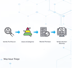
Map Issue Triage involves analyzing real-world data to detect navigation issues, ensuring smooth and safe autonomous operations. It plays a key role in maintaining and updating maps for reliable performance.
DDD offers GIS Map Creation training and a skilled team of 100+ operators actively engaged in these projects.
We provide holistic navigation and mapping solutions for the highest efficiency and accuracy.

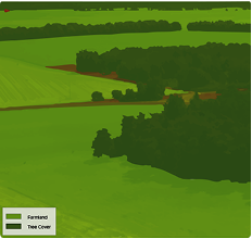
Aerial imagery labeling assigns tags to drone, satellite, and aerial images for tasks like object detection and segmentation. Applications span agriculture, urban planning, environmental monitoring, disaster response, and infrastructure inspection.
DDD has supported Space Agencies, Satellite Data Providers, and AgTech firms with precise aerial imagery labeling services.
We provide holistic navigation and mapping solutions for the highest efficiency and accuracy.

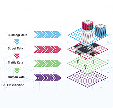
GIS Classification organizes geographic data into categories, simplifying analysis for mapping, urban planning, and resource management, revealing patterns that aid decision-making across industries.
DDD’s trained workforce specializes in cartographic datasets, ensuring high-quality GIS classification.

High-quality maps and navigation are the foundation of autonomous systems, enabling precise decision-making for self-driving systems, robotics, and mobility applications. Our Navigation & Maps Solutions provide accurate, structured, and scalable mapping services tailored for diverse use cases, from Autonomous Vehicles (AVs) and ADAS to AgTech, Satellite Imagery, and GIS applications.
Strategic
We bring industry-tested SMEs, provide training data strategy, and understand the data security and training requirements needed to deliver better client outcomes.
Reliable
Our global workforce allows us to deliver high-quality work, 365 days a year, across multiple countries and time zones. With 24/7 coverage, we are agile in responding to changing project needs.
Consistent
We are lifetime project partners. Your assigned team will stay with you - no rotation. As your team becomes experts over time they train more resources, that's how we achieve scalability.
Flexible
We are platform agnostic. We don't force you to use our tools, we integrate with the technology stack that works best for your project.

Deep dive into the latest technologies and methodologies that are shaping the future of autonomous driving.

Reliable Data Annotaion for Autonomous Driving System Demands a Disciplined Methodology
Read white paper